
Tripura
Tripura is one of the ‘seven sisters’ states of India and shares its borders with Bangladesh, Mizoram and Assam. The Sanskrit name is linked to ‘Tripur Sundri” the presiding deity of Tripura. There are many ethnic groups in the state such as Tripuri, Garo, Munda, Oran and as many as 14 more. The bamboo and cane handicrafts in the state are very popular. Music and dance are also an important part of the culture of the state; people have their own set of songs and dances which they perform during different occasions. Jhum dance, lebnag dance, mamita dance are some of the popular dance forms of the state. Palaces, temples and wildlife sanctuaries draw maximum tourists to the state.
Tripura (/ˈtrɪpʊrə, –ərə/)[8] is a state in northeastern India. The third-smallest state in the country, it covers 10,491.69 km2 (4,050.86 sq mi) and is bordered by Bangladesh to the north,[9] south, and west, and the Indian states of Assam and Mizoram to the east. In 2011 the state had 3,671,032 residents, constituting 0.3% of the country’s population.
The area of modern Tripura—ruled for several centuries by the Manikya dynasty—was part of an independent princely state under the protectorate of the British Empire. The independent Tripuri Kingdom (also known as Hill Tippera) joined the newly independent India in 1949.
Divisions[edit]
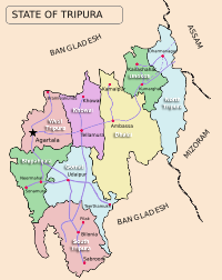
Tripura district map
In January 2012, major changes were implemented in the administrative divisions of Tripura. Beforehand, there had been four districts – Dhalai (headquarters Ambassa), North Tripura (headquarters Kailashahar), South Tripura (headquarters Udaipur, Tripura), and West Tripura (headquarters Agartala). Four new districts were carved out of the existing four in January 2012 – Khowai, Unakoti, Sipahijala and Gomati.[54] Six new subdivisions and five new blocks were also added.[55] Each is governed by a district collector or a district magistrate, usually appointed by the Indian Administrative Service. The subdivisions of each district are governed by a sub-divisional magistrate and each subdivision is further divided into blocks. The blocks consist of Panchayats (village councils) and town municipalities. As of 2012, the state had eight districts, 23 subdivisions and 58 development blocks.[56] National census and state statistical reports are not available for all the new administrative divisions, as of March 2013. Agartala, the capital of Tripura, is the most populous city. Other major towns with a population of 10,000 or more (as per 2015 census) are Sabroom, Dharmanagar, Jogendranagar, Kailashahar, Pratapgarh, Udaipur, Amarpur, Belonia, Gandhigram, Kumarghat, Khowai, Ranirbazar, Sonamura, Bishalgarh, Teliamura, Mohanpur, Melaghar, Ambassa, Kamalpur, Bishramganj, Kathaliya, Santirbazar and Baxanagar.
Transport[edit]
Air
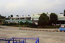
Maharaja Bir Bikram Airport
Maharaja Bir Bikram Airport, located 12 km northwest of Agartala at Singerbhil, is the second busiest airport in northeast India after Guwahati. There are direct flights to Kolkata, Imphal, Delhi, Shillong, Guwahati, Bangalore, Chennai, Ahmedabad and Mumbai. The major airlines are AirAsia India, Air India and Indigo Airlines.[88] Passenger helicopter services are available between the capital and major towns (Kailashahar, Dharmanagar) as well as to more remote areas such as Kanchanpur, Belonia and Gandacherra.[89]
Railway

Agartala Railway Station
Agartala, came on India’s railway map with the advent of the railways in the subcontinent in 1853 but the link was broken when India was partitioned in 1947. Railway service was established in Tripura in 1964 by constructing 1,000 mm (3 ft 3+3⁄8 in) metre gauge track from Lumding in Assam to Dharmanagar and Kailasahar in Tripura but the track did not connect the state capital Agartala. Rail transport was absent in the state until 2008–09 when the railway track was extended to the capital Agartala
Road
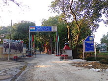
The border post between Bangladesh and India in Akhaura
Only one major road, the National Highway 8 (NH-8), connects Tripura to the rest of India.[89] Starting at Sabroom in southern Tripura, it heads north to the capital Agartala, turns east and then north-east to enter the state of Assam. Locally known as “Assam Road”, the NH-8 is often called the lifeline of Tripura.[89] However, the highway is single lane and of poor quality; often landslides, rains or other disruptions on the highway cut the state off from its neighbours.[36]:73[77]:8 Another National Highway, NH 108, connects the town Panisagar in North Tripura District with Aizawl, Mizoram.[35] The Tripura Road Transport Corporation is the government agency overlooking public transport on road. A hilly and land-locked state, Tripura is dependent mostly on roads for transport.[89] The total length of roads in the state is 16,931 km (10,520 mi) of which national highways constitute 88 km (55 mi) and state highways 689 km (428 mi), as of 2009–10.[89] Residents in rural areas frequently use waterways as a mode of transport.[90]:1
Population[edit]
| Population growth[123] | ||
| Census | Population | %± |
|---|---|---|
| 1951 | 639,000 | — |
| 1961 | 1,142,000 | 78.7% |
| 1971 | 1,556,000 | 36.3% |
| 1981 | 2,053,000 | 31.9% |
| 1991 | 2,757,000 | 34.3% |
| 2001 | 3,199,203 | 16% |
| 2011 | 3,671,032 | 14.7% |
Tripura ranks second to Assam as the most populous state in North East India. According to the provisional results of 2011 census of India, Tripura has a population of 3,671,032 with 1,871,867 males and 1,799,165 females.[124] It constitutes 0.3 per cent of India’s population. The sex ratio of the state is 961 females per thousand males,[124] higher than the national ratio 940. The density of population is 350 persons per square kilometre.[125] The literacy rate of Tripura in 2011 was 87.75 per cent,[124] higher than the national average 74.04 per cent, and third best among all the states.
Tripura ranked 6th in Human Development Index (HDI) among 35 states and union territories of India, according to 2006 estimate by India’s Ministry of Women and Child Development; the HDI of Tripura was 0.663, better than the all-India HDI 0.605.
